Description:
Multi-channel analysis of surface wave (MASW) seismic methods are useful where the survey goal or target of interest might not be detected using standard refraction seismic methods, or where site conditions preclude the use of seismic refraction, or where a combined MASW and refraction microtremor (ReMi) approach is needed to develop a detailed site specific seismic Site Class for purposes of engineering design calculations.
In situations where expected caliche or cemented soil layer(s) overlie less dense soils, or where bedrock including varying layers of soft and hard rocks (example: claystone interbedded with sandstone units), or if surface or buried pavements or other infrastructure like existing slab on grade foundation or buried concrete box culverts are present within or under the planned survey location, standard refraction seismic methods cannot be performed because such existing materials likely have a higher P-wave velocity than the underlying soil materials of interest. These situations create a "velocity inversion" situation that precludes the seismic refraction method from working properly. Such velocity inversion conditions are usually either recognizable in the field during data collection, or from a desktop study of the geologic background for a site before field work is initiated, or from a combination of both.
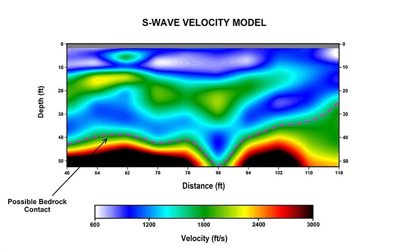
When such conditions are recognized we often propose that (MASW) roll-along seismic methods be used. The data is collected using a Geometrics StrataView or Geode 24 channel digital seismograph unit and a 24-channel landstreamer unit with 4.5 hertz (Hz) center frequency geophones. The MASW technique uses recorded surface waves (specifically Rayleigh waves) to develop an approximate shear wave velocity profile of the site. Unlike the conventional refraction method, the MASW method does not require an increase of material velocity with depth. Therefore, low velocity zones (velocity inversions) are often detectable using MASW, and existing layer velocity inversions do not preclude collection of useful data. Recorded MASW data is processed and analyzed using either Geometrics SeisImager/SW software package, and/or SurfSeis 5 (Kansas Geological Survey) software for comparison of seismic model results. The resulting two-dimensional (2-D) MASW model is presented as a model of s-wave velocity versus depth, which can be correlated to approximate P-wave velocities, and associated estimated material rippability, depth to caliche, depth to cemented soils, and/or bedrock.
In some situations using MASW methods it is also possible to image and map positions of buried channels, earth fissure zones, voids, waste trenches, and landfills, especially when MASW is combined with results from other geophysical methods conducted over the same study area.